

MapItFast- Field-based Mapping

4.2star
69 reviews
10K+
Downloads

Everyone
info


About this app
MapItFast turns your phone or tablet into a powerful mapping and record-keeping device, even in the backcountry while offline. One-tap mapping makes it easy to create points, lines, polygons, and geophotos to represent anything of interest in the field. Take it to the next level and use your own maps and custom electronic forms to record fieldwork that is seamlessly synchronized into your own cloud account.
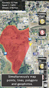
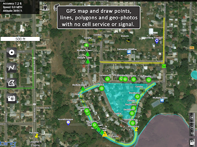
Mapping is super fast. You can tap the map object icons to create objects using GPS or long-press the icons to draw objects in by hand. Instantly view geophotos and display location information such as distance and area covered.
Pause and resume GPS tracking. Create multiple GPS lines or polygons at the same time. Drop points, take geophotos, and draw objects by hand without interrupting GPS tracking. Organize your mapping into projects to create your own custom atlas.
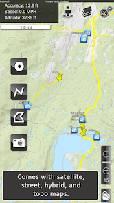
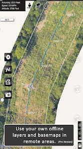
Arial, street, and topo basemaps come included to give you a clear reference for your mapping.
*****
MapItFast Professional is a paid version of the app designed for enterprise use with virtually no training or GIS knowledge required.
The paid version of MapItFast synchronizes projects and users on Android and Apple devices into your private cloud-based account. This enables you to make data collection more efficient as you collaborate on an unlimited number of projects and use your own custom designed forms to link data with map objects.
Paid version features include:
• Cloud-based account with maps and data synced across devices and the web
• Web-based portal to view projects, users and shared contributions in real time
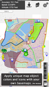
• Ability to load and distribute your own custom, maps and symbology
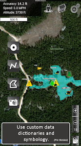
• Integrated electronic forms to add attributes to map objects directly from the app
• Triggers that automatically change map symbols based on how a form is filled out
• Printable and emailable reports you customize with company logos, filled data, maps, photos and more
• GIS mapping tools such as object buffers, splits and donuts
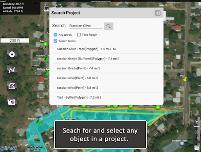
• Searching, editing, sorting, copying, moving map objects among projects
• Importing shapefiles as editable map objects or as layer overlays
• Exporting to any GIS using formats including KMZ, Shapefile (SHP) and GPX
• Two-way, real-time synchronization between field devices and your online account
• User and group level project access and permissions
*****
Additional plugins allow you to automate mapping even further by connecting AgTerra's datalogging products to your mobile device.
• SprayLogger is specially designed to collect every detail for pesticide applications and generate automatic detailed reports.
• SnapMapper allows users to quickly creat points and lines in MapItFast with the flip of a switch from any mechanical device.
Field workers and natural resource professionals are currently using MapItFast for activities such as:
• Vegetation management & pesticide application reporting
• Mosquito trap inspection and vector control recording and reporting
• Inspections/ field surveys
• Crop scouting
• Wildfire and disaster response and prevention
• Rangeland management
• Water management
• Utility work
• Forestry monitoring/ timber cruising
Simplify mapping and easily manage data while improving field workforce efficiency for the entire organization. See more details in the product video. Learn more about all our products at www.agterra.com
Mapping is super fast. You can tap the map object icons to create objects using GPS or long-press the icons to draw objects in by hand. Instantly view geophotos and display location information such as distance and area covered.
Pause and resume GPS tracking. Create multiple GPS lines or polygons at the same time. Drop points, take geophotos, and draw objects by hand without interrupting GPS tracking. Organize your mapping into projects to create your own custom atlas.
Arial, street, and topo basemaps come included to give you a clear reference for your mapping.
*****
MapItFast Professional is a paid version of the app designed for enterprise use with virtually no training or GIS knowledge required.
The paid version of MapItFast synchronizes projects and users on Android and Apple devices into your private cloud-based account. This enables you to make data collection more efficient as you collaborate on an unlimited number of projects and use your own custom designed forms to link data with map objects.
Paid version features include:
• Cloud-based account with maps and data synced across devices and the web
• Web-based portal to view projects, users and shared contributions in real time
• Ability to load and distribute your own custom, maps and symbology
• Integrated electronic forms to add attributes to map objects directly from the app
• Triggers that automatically change map symbols based on how a form is filled out
• Printable and emailable reports you customize with company logos, filled data, maps, photos and more
• GIS mapping tools such as object buffers, splits and donuts
• Searching, editing, sorting, copying, moving map objects among projects
• Importing shapefiles as editable map objects or as layer overlays
• Exporting to any GIS using formats including KMZ, Shapefile (SHP) and GPX
• Two-way, real-time synchronization between field devices and your online account
• User and group level project access and permissions
*****
Additional plugins allow you to automate mapping even further by connecting AgTerra's datalogging products to your mobile device.
• SprayLogger is specially designed to collect every detail for pesticide applications and generate automatic detailed reports.
• SnapMapper allows users to quickly creat points and lines in MapItFast with the flip of a switch from any mechanical device.
Field workers and natural resource professionals are currently using MapItFast for activities such as:
• Vegetation management & pesticide application reporting
• Mosquito trap inspection and vector control recording and reporting
• Inspections/ field surveys
• Crop scouting
• Wildfire and disaster response and prevention
• Rangeland management
• Water management
• Utility work
• Forestry monitoring/ timber cruising
Simplify mapping and easily manage data while improving field workforce efficiency for the entire organization. See more details in the product video. Learn more about all our products at www.agterra.com
Updated on
Safety starts with understanding how developers collect and share your data. Data privacy and security practices may vary based on your use, region, and age. The developer provided this information and may update it over time.

No data shared with third parties
Learn more about how developers declare sharing

This app may collect these data types
Location and Photos and videos

Data is encrypted in transit

You can request that data be deleted
Ratings and reviews
4.3
48 reviews

shawn baham
- Flag inappropriate
February 12, 2024
Barely works, needs a serious rework of the coding to work better and half the time it crashes and the other half the icons are miles from where they should be.

A Google user
- Flag inappropriate
February 27, 2019
Excellent support both online and in person.
4 people found this review helpful
A Google user
- Flag inappropriate
January 11, 2020
Takes a while to load and laggish graphics
9 people found this review helpful
What's new
Update to 3rd party mapping
Update to offline vector layers for continually moving maps
Update to weather data gathering
Update to Job menu close button behavior
Update to offline vector layers for continually moving maps
Update to weather data gathering
Update to Job menu close button behavior
App support
phone
Phone number
+13076731050
